Prag 11
Stadtteil von Prag

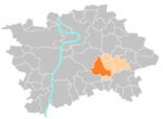
Prag 11 ist ein Verwaltungsbezirk sowie ein Stadtteil der tschechischen Hauptstadt Prag. Der Verwaltungsbezirk liegt am südlichen Rand der Stadt.
Auszug des Wikipedia-Artikels Prag 11 (Lizenz: CC BY-SA 3.0, Autoren, Bildmaterial).Prag 11
Ocelíkova, Hauptstadt Prag Haj
Geographische Koordinaten (GPS) Adresse Webseite In der Umgebung Auf Karte anzeigen
Geographische Koordinaten (GPS)
| Breitengrad | Längengrad |
|---|---|
| N 50.028611111111 ° | E 14.531666666667 ° |
Adresse
Úřad městské části Praha 11 (ÚMČ Praha 11)
Ocelíkova 672/1
149 00 Hauptstadt Prag, Haj
Prag, Tschechien
Bei Google Maps öffnen


